Travel Management Planning

A Travel Management Plan (TMP) is like a rulebook, established by the Bureau of Land Management (BLM), for recreation on public lands. TMPs outline where people can and can’t use vehicles like cars, trucks, or ATVs on public lands. It outlines areas that can only be accessed by foot or areas that are completely closed to the public. These plans should always provide opportunities for access, economic prosperity, and stewardship.
However, recent TMPs are only restricting access and causing a ripple effect of negative impacts in Utah. Accordingly, the State of Utah opposes the closure of any road that limits multiple-use and sustained yield activities on public Lands administered by the BLM as required by the Federal Land Policy and Management Act (FLPMA).
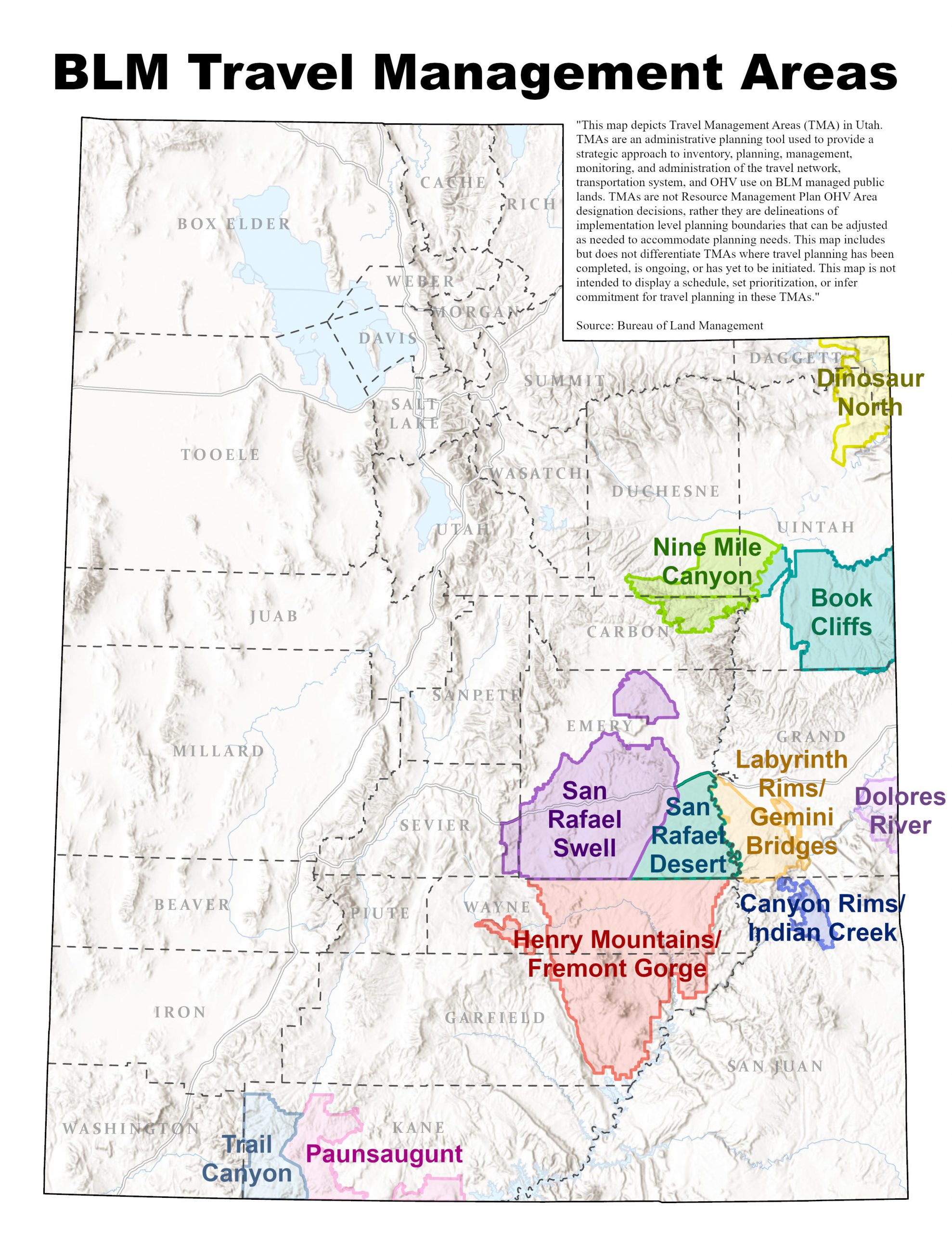
BLM Travel Management Areas
The State of Utah (State) through the Public Lands Policy Coordinating Office (PLPCO) and the Public Lands Section of the Office of the Attorney General work diligently to coordinate, promote, and implement Utah's public land priorities.
This page only encompasses Travel Management Plans (TMPs) in Travel Management Areas (TMPs) administered by the Bureau of Land Management (BLM). TMPs are a component of larger land use plans.
The State also works on other types of land use planning with the U.S. Forest Service, BLM, and other public land agencies.
Travel Management Areas

Dinosaur North Travel Management Plan
Trail Canyon Travel Management Plan
Dolores River Travel Management Plan

San Rafael Swell Travel Management Plan

San Rafael Desert Travel Management Plan

Book Cliffs Travel Management Plan

Canyon Rims / Indian Canyon Travel Management Plan
Labyrinth Rims / Gemini Bridges Travel Management Plan

Henry Mountains & Fremont Gorge

Nine Mile Canyon Travel Management Plan

Paunsaugunt Travel Management Plan
What is a Travel Management Plan (TMP)?
The BLM defines a TMP as a comprehensive travel and transportation management plan including a wide ranging analysis considering the access needs of public lands users. Access needs are evaluated in conjunction with BLMs legal mandate to protect natural and cultural resources on public lands. Routes included in the TMP will be analyzed in [and] through the National Environmental Policy Act (NEPA) process. Federal law requires specific evaluation and designation for public motorized uses, referred to in regulation as off highway vehicles (OHVs).
TMP closures by the BLM mean less access to public lands for all users. The State of Utah believes in providing the most access for all users of all ages and abilities, so the State opposes closing any existing access to public lands.
Travel Management Planning in Utah
Why is the BLM completing so many TMPs in Utah?
On May 31, 2017 a settlement agreement was reached in the case
titled Southern Utah Wilderness Alliance, et al. v U.S Department of the Interior, et al.. This agreement has significant implications for travel and transportation planning efforts in the Richfield, Price, Moab, Kanab, and Vernal Bureau of Land Management (BLM) field offices.
As a result of this settlement agreement, the BLM is required to
complete Travel Management Plans (TMPs) for 11 Travel Management Areas (TMAs) in Utah (map).
What is a BLM Travel Management Plan (TMP)?
According to the BLM website, a "comprehensive travel and
transportation management plan includes a wide-ranging analysis
considering the access needs of public lands users. Access needs are evaluated in conjunction with BLM’s legal mandate to protect natural and cultural resources on public lands. Individual route evaluations and designations included in the TMP will be analyzed in [and] through the National Environmental Policy Act (NEPA) process. Federal law requires specific evaluation and designation for public motorized uses, referred to in regulation as off-highway vehicles (OHVs). Based on this analysis every BLM route within the TMA will receive designation for its use types or use limitations."
What are the public land access implications that can result from a TMP on public lands administered by the BLM?
Subject to existing and valid rights, the BLM can, through a TMP public planning process, determine to open, close, modify, and/or add new routes, or otherwise consider or institute management prescriptions in accordance with applicable laws and regulations.
In short, whenever a new TMP is created, or a TMP is amended, it will result in closed routes and fewer access options for recreation and other multiple-use and sustained yield activities on public lands.
How can the public participate in a BLM TMP?
Submit a comment letter during BLM comment periods!
Use this guide to help you write a substantive comment.